Located just 30 minutes north of Dublin in the North East of Ireland and at the heart of Ireland's Boyne Valley, County Meath can boast an unrivalled and enviable location with four major motorways - the M1, M2, M3 and M4 - passing through the county.
Air and Sea
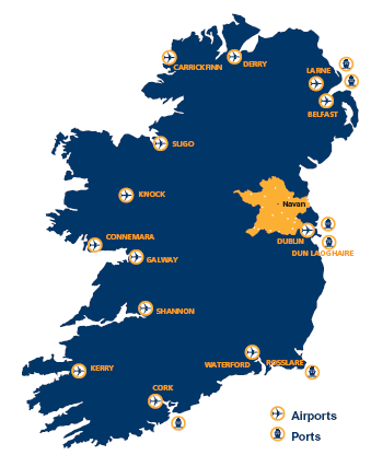
County Meath is located only 30 minutes from Dublin International Airport while the ferry ports in Dublin, Dun Laoghaire and Belfast are also convenient.
Rail
Meath is linked by rail via the Dublin-Belfast line through Drogheda (at Laytown and Gormanston), the M3 Parkway-Dublin line (via Dunboyne) and in the south at Enfield (on the Dublin to Sligo line). For timetables and fares see irishrail.ie
Bus
A number of bus routes operate through Meath and Louth, linking the main towns such as the 109 (Dublin to Cavan via Navan and Kells), the 111 (Dublin to Athboy via Trim) and the 190 (Trim to Drogheda via Navan and Slane).
NB: Bus Eireann operates a bus service (Route 163) between the Brú na Bóinne Visitor Centre and Drogheda, via the Battle of the Boyne site at Oldbridge House. See all national bus information see buseireann.ie.
Local Link operates a number of bus routes in Meath (including Ashbourne, Longwood, Trim, Navan and Athboy), Louth (including Drogheda, Clogherhead, Annagassassan and Monasterboice) and Fingal. See website for details.
Electric Vehicles (EV) Charging Stations in Meath
For information on Electric Vehicles (EV) Charging Stations in Meath click here.
Click here for an interactive map of charge point locations in Meath.