What is being Proposed
Meath County Council is proposing to develop the Dunboyne and Clonee Pedestrian and Cycle Network, which will provide high quality, safe, continuous and consistent cycle and pedestrian facilities in Dunboyne and Clonee.
The proposed network will improve pedestrian and cyclist safety and mobility and will facilitate local recreational usage along with functional access to schools, employment, amenities and services.
The proposed network will also facilitate linkage to other networks being developed in Fingal, enabling access to employment areas further afield.
The Strategic Vision
A transition towards more sustainable modes of transport is essential to reduce Ireland’s carbon emissions and reach the Government’s goal to reduce carbon emissions to 30% by 2030 and 80% by 2050.
The development of the proposed pedestrian and cycle network in Dunboyne and Clonee is fundamental to this strategic vision as it will deliver sustainable transport facilities and promote the usage of such facilities, which aligns with objectives of numerous national, regional and local government polices to reduce private car usage and associated emissions.
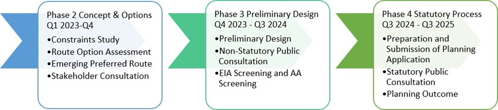
Project Scope and Anticipated Time Line
The proposed network is currently in Phase 2 Concept and Options. Stakeholder consultation throughout all phases will be ongoing and it is intended that a non-statutory public consultation will take place at the end of the Phase 2.
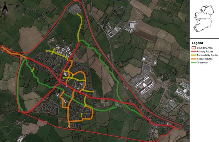
Study Area Map
The proposed network will cover the main roads and streets leading into and through the towns of Dunboyne and Clonee, in addition to a number of residential access roads and links and other off road routes. The project aims to develop a cycle and pedestrian network consisting of primary routes, feeder routes, permeability routes and greenways. This will account for over 20 km of new and upgraded pedestrian and cycle facilities. The extents of the proposed network is shown in the Study Area Map below.
Next Steps
Further communication on the project will be made as completion of Phase 2 Concept and Options is approached.
In the interim, should you have a query, question or any relevant information that you would like to share please contact us at:
Email: activetravel@meathcoco.ie Tel: (046) 9097150